Vision:
Cultural Restoration, images of a new relationship to stormwater and lost
streams
Issue:
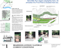
Water flow is a safety concern. Invitation for more people to
view a natural phenomenon, means we have to address the safety concerns.
Opportunities:
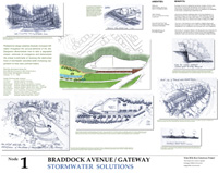
- Culvert steps should be designed for sitting and watching and provide access for maintenance vehicles
- Establish a warning system for storm surge, provide points of egress.
- Public art opportunity whereby/bells or other devices can be activated by storm outflows
- Establish a "stream mark" beginning at Braddock Ave. which can be used to outline the culverted stream in the upper watershed communities
- Create community ed center/info at foodland entrance
- Target homeowners to education about benefitting the stream
- Explore corporate sponsorship of homeowner retrofit
- Municipal partnerships should be highlighted here
Goals:
- Celebrate the water
- Create cultural
connections
- Increase/expand
access to the park
- Encourage community education through pro-active signage and icons
Challenges:
- Address difficult storm events
- Constrain access
to the culvert
- Floatables control
- collect debris, allowing for the flow of water
- Traffic at the entrance is a problem
- Action: Focus on the design as a local PEDESTRIAN access point
- Should allow maintenance equipment, and cleanout access to the stilling pond
- Maintain parking for business
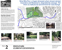

Vision:
- Ecological restoration which separates the stream ecosystem from sewer infrastructure
- Restore the floodplain, stabilize waterflow and minimize sewage impact
- Restoration model for region
- CSO management model for country
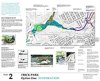
Goals:
- Transform the lower Frick Park experience
- Create a better ballfield in a new location
- Add stream meanders and flood plain
- Use natural materials and minimize concrete wherever possible.
- Design, plan and institutionalize sustainability
Opportunities:
- Interpret, information-
education and establishing signage
- Trail design for
mountain bikers
- Create limited walkways in sensitive areas for ADA access and education
Challenges:
- Reconsider parking- Fern Hollow Creek relationship
- Make sure peak parking use is accommodated
- Design with permeable surface or other appropriate stormwater applications
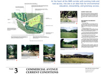
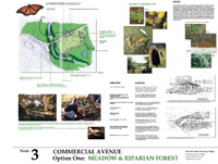
Vision:
A meadow restoration would provide the best possible design
solution given the greenway goal of restored and supported healthy diverse
ecosystem.
Goals:
An integrated design including a ballfield,
a meadow restoration and an interpretive center on this singular site.
Each element should embrace multi-benefit solutions and a green design
program targeting innovative structure, utilities and systems.
Guidelines:
- Construct a Commercial Avenue pedestrian crossway just south of the parkway bridge with user-activated traffic control
- Use the Summerset
entrance and its periphery for vehicular access and parking
- Create a sidewalk on the URA (slag) side of the road
- Put the interpretive center close to the stream but visible from the pedestrian crossing
- If the Commercial Avenue bridge is reconstructed, refurbish the underpass in such a way as to be wildlife friendly
- Design the playing field to mitigate stormwater flow
- Preserve as much meadow as possible
- Develop the interpretive center with an onsite steward and integrate the ecological reality of the site into the body of the architecture
- Explore the possibility of removing the concrete fill, and dropping the entire field to its historic floodplain
- Use no pesticides or herbicides in the management of the site
- No ballfield lighting, no sound sytem
Opportunities:
- Design the site for multi-benefit use, realize diverse human needs and create a threshold for the diverse audience to access an ecosystem based experience
- Explore the potential for the existing field to be lowered, allowing for dual function as playing field and ecologically designed flood plain
- Design the ballfield and its meadow environment in such a way that stormwater runoff from the Parkway and Commercial Avenue can be detained, cleaned and infiltrated into the groundwater
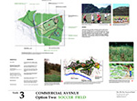
Challenges:
- Pedestrian crossing of the road is a problem
- Parking and vehicular entry onto Commercial is an issue
- Anything that adds to the traffic will negatively affect the wildlife
- The playing field will interrupt the ecosystem and minimize biological connectivity at a key point in the greenway -- this is counter to the greenway-plans stated vision and goals
Conflict
and Resolution:
While the preference is for a meadow restoration, the
community planners recognize the value of diverse human uses and recognize
the need for ballfields in Pittsburgh. If there is to be a ballfield at
this site, it must consider the above goals and guidelines.

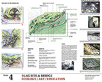
Issue:
Maintaining silence in the quietest point in the greenway.
Vision:
Restore the site through a mix of ecological and cultural processes.
Target education, art and revegetation.
Opportunities:
- The stream (clean and ecologically restored!)
- Existing bridge and its downstream area
- Two areas of
existing floodplain: shale
cliffs, natural soils and Trillium on the North facing bank
Challenges:
- Equitable handicap access
- Integrating the Summerset bridge into the intent of the greenway
Goals:
-
Renovate the existing bridge for pedestrians
-
Provide public access to the stream
-
Revegetate steep slopes using natural succession processes
-
Celebrate the heart of the greenway with ecological art
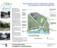
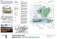
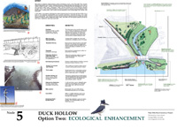
Vision:
Restored riparian ecosystem, minimal effort maximum benefit.
Issue:
- Safe pedestrian connectivity between the slag entry and Duck Hollow.
- Bus service for residents and recreational users.
Goals:
- Celebrate the entry to the slag site/trail.
- Enable public access to the stream and river.
Opportunities:
- Army Corp of Engineers project to improve the aquatic habitat in the NMR embayment.
- Duck Hollow/flood plain wildlife sanctuary (complimenting the above).
- Celebrate the Greenway entry with a butterfly-habitat garden.
- Simple kiosk with water, toilets, fishermans sink, info board, locking bike rack.
Challenges:
- Mon-Fayette Expressway (Potential public trail investment opportunity)
- Pedestrian safety under the existing RR bridge.
- Property ownership.