Table of Contents
 (from p63-75)
 
Table of Figures
Section VII - Metropolitan District Problems, Water Recreation 63-71
Distribution of Recreation Centers
63
Large Parks - An Outer Boulevard System
63
A Public Forest
63
Water Recreation
64
Ohio River Islands - Chartiers Valley
64
Allegheny River Water Front - Squaw Run
64
Nine Mile Run Valley
65

Table of Figures
 (from p63-75)
 
Allegheny valley Topographical map 64
General View looking up Nine Mile Run Valley from Calvary Cemetary 65
This view of an outing upon the water at Belle Isle park, Detroit, suggests a similar use for Nine Mile Run Valley. View furnished by Department of Parks, City of Detroit 65
View in Nine mile Run Valley at lower end of Commercial Avenue, looking southwest 67
View in Nine mile Run Valley, looking east towards Swissvale 67
Nine Mile Run Valley and Vicinity showing Topographical Contours 68
Pittsburgh Metropolitan Recreation Centre in Nine Mile Run Valley 69
Looking up Fern Hollow from its junction with the main Nine Mile Run Valley 70
View in Nine Mile Run Valley  70


Citizen's Committee Report
The following images and text have been excerpted from Parks: A Part of the Pittsburgh Plan, Report No. 4 by the Citizen's Committee on City Plan of Pittsburgh, September, 1923
SECTION VII
 METROPOLITAN DISTRICT PROBLEMS - WATER RECREATION
 
Recognizing the fact that the City of Pittsburgh is the center of a very large metropolitan district population, the Committee believes that provision of park land should be made throughout this populous community. There are four phases of this problem to which consideration should be given by local officials and planning bodies and by the Allegheny County Planning Commission. These phases are listed below and followed by suggestions covering the first three, and recommendations concerning the fourth.

 
1.
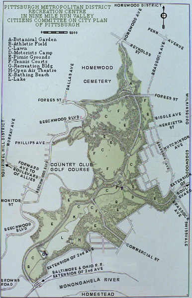
Distribution of centers for combined school, playground, athletic field and neighborhood park use. 
2.
Allocation of larger parks, comprising some of the existing wooded ravines and land of other character, together with an outer boulevard system. 
3.
Location and development of a city or county "forest." 
4.
Location and development of adequate water recreation facilities upon a larger scale. 
Distribution of Co-ordinated Local Recreation Centers (back to Table of Contents)


Provisions of this kind become increasingly necessary as the environs of Pittsburgh increase in population. In territory now partially or entirely vacant, larger and more adequate parcels of land can be acquired, at less cost, than is possible within the city. In some localities, there is ideal opportunity to reserve tracts of from twenty to thirty acres for such centers. Before any such scheme can become practicable, it will be necessary to plan the major and minor thoroughfares of the territory; to make studies forecasting the population (and especially the number of children) upon the land; to secure cooperation between municipal and school board officials; and to adopt a land acquisition policy adjusted to the desired program.


Large Parks - An Outer Boulevard System (back to Table of Contents)


No outer boulevard system can be properly devised until after the County Planning Commission has thoroughly studied and prepared a Major Highway Plan for the County. A study of this subject is now under way. After the main traffic highways are determined and due precedence given to the improvement of these commercial arteries, it will be possible to select from among them and from the minor highways the proper roads to form a system of boulevards for the circulation of pleasure vehicles. Upon the basis of a reasonable boulevard system of this kind, decision can be made as to the acquisition of park lands adjacent to these roadways.
It is a fact that the traditional and locally prevalent width of 33 feet for county roads is entirely inadequate for any major traffic highway or for a county boulevard. With respect to the latter, it is evident that an existing road selected as part of a boulevard system, or a new road to be built for such purpose, should be ample enough to provide for three lines of vehicles (27') in the more open stretches of country and a minimum of four lines of vehicles (36') where the road passes any considerable number of developed building lots. If a boulevard character is to be permanently assured, border strips of land should be acquired upon both sides of the roadway for planting of trees, etc. These border strips should, wherever possible, be of generous width - say a minimum of 20 to 30 feet each - and may, in particular places, be made even larger in order to include and preserve some attractive natural feature, such as a fine tree, a group of trees, or a smallwooded ravine. The foregoing should not be construed as either a recommendation or a suggestion applicable to the County's main traffic highways, as the latter are not discussed in this report.


A City or County "Public Forest" (back to Table of Contents)


...It will be noted that several cities have park lands beyond the city limits. The Cook County Forest Preserve surrounding Chicago and the Metropolitan Park Commission's developments around Boston are notable examples. It is here noted that some of the larger parks and certain other properties (at the Mayview "City Home," the Tuberculosis Hospital site at Leech farm, and the County Farm above Aspinwall) have sufficient area for the planting of additional trees. But the Committee calls attention to the fact that none of these are suitable for a forest because of the necessity for other uses to which they are now devoted, and because their size is not adequate for a combination of the present uses with use as a forest. It appears to this Committee that a public forest would be a most desirable special type of recreation area to provide, but that its location and development are a metropolitan district problem. It is suggested that very careful consideration be given thereto by the County Planning Commission, and that the selected site should be one which is both large in size and can be made accessible by a perfected scheme of county road circulation. Moreover, it would also be desirable that a public forest should be not only accessible by automobile but also accessible through the use of electric or steam transportation routes for a major portion of a visitor's journey.
In passing it may be but briefly noted that a public forest affords camping and outing facilities for vacationists and is very valuable as a preserve for plant, animal and bird life.


Water Recreation (back to Table of Contents)


Although the Public Safety Department of Pittsburgh supervises some fifteen swimming locations along the local rivers within the City of Pittsburgh, there is no water front park in the city. Moreover, beyond the city limits, the inadequacy of water recreation facilities (such as those at Oakmont and Sewickley) to serve the great mass of population in the congested centers indicates that this phase of metropolitan district recreation is especially important. It should give especial concern to industrial and other employers. There appears to be a widely held belief, easily to be credited, that in the minds of workers the water recreation facilities of other cities often overbalance the inducement of a higher wage rate in Pittsburgh.
Any water recreation facilities for this region must be located upon the Monongahela, Allegheny or Ohio rivers, or upon artificial lakes created in tributary valleys or ravines. It is desirable also that the maximum number of people of the metropolitan district should be able to reach any such facilities without too much inconvenience or the expenditure of too much money. This Committee is of the opinion that in time three centers may be needed and developed in the three river valleys respectively. For the present, the Committee suggests concentration upon a program to develop but one - the Nine Mile Run site, adjacent to the Monongahela valley.


In the Ohio valley the only reasonable sites to be considered are (1) in the adjacent Chartiers valley between Sheraden and McKees Rocks, and (2) upon one or another of the Ohio river islands. The first of these sites is difficult of access, except locally. On the other hand, the river islands could be reached by excursion boats but are otherwise not very accessible to the people of the metropolitan district. Although development of the Ohio river center is probably in the remote future, the significance of this kind of use upon one of the islands should not be lost sight of. 
In the Allegheny valley the most reasonable sites are, in order of their desirability: (1) a privately owned and excellent industrial site on the north bank of the Allegheny river extending from the County Poor Farm down almost to the filtration plant at Aspinwall; (2) Squaw Run ravine, including the adjacent hillsides, immediately northeast of the filtration plant and probably extending up the run to the place where it adjoins Delafield Road, and (3) the river front portion of the county property at the County Poor Farm. Site No. 1 will most likely be developed by the owners before any public recreation development in the locality is actually undertaken. Site No. 2 offers decided opportunities for attractive and serviceable development.

There could be no serious objection to developing a plan and acquiring this site at a reasonably early date, after the Monongahela valley project is started. Site No. 3 is slightly less desirable than No. 2, being somewhat farther from the population centers; but it has the advantage of location directly upon the river. The three sites are, however, not so accessible to the metropolitan population as is the Nine Mile Run site described later. 

GENERAL VIEW LOOKING UP NINE MILE RUN VALLEY FROM CALVARY CEMETERY
 (back to Table of Figures)
In the Monongahela valley proper there is no accessible and suitable location for water recreation. The adjacent tributary of Nine Mile Run offers special opportunity for a desirable kind of development although its area will not permit the creation of an artificial lake of more than modest size. This valley has two branches. One branch, beginning at the south end of Homewood Avenue, is locally known as "Fern Hollow." It adjoins the Homewood Cemetery and passes through the Frick Park tract. (See Topographical Map). The other branch, leading southwestward from Edgewood and Swissvale, joins the first and forms a wider and more ample valley extending to the point where the run empties into the Monongahela River, at Brown's Bridge, opposite Homestead. The accompanying view from Calvary Cemetery, looking up the valley, and showing the river at the extreme right, gives a fair idea of this as yet undeveloped territory. The topographical map shows the location of this valley in relation to the surrounding street system.


 THIS VIEW OF AN OUTING UPON THE WATER AT BELLE ISLE PARK, DETROIT, SUGGESTS A SIMILAR USE IN NINE MILE RUN VALLEY. VIEW FURNISHED BY DEPARTMENT OF PARKS, CITY OF DETROIT
 (back to Table of Figures)
 
 
The following points should be cited before indicating any special proposals, namely:

 
(1)
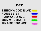
A most important new crosstown thoroughfare through the valley and Fern Hollow is recommended as route No. 48 of the Major Street Plan. It should be a six-line thoroughfare with appropriate additional width; for example, if no park project is undertaken a width of 100 feet should be secured. 
(2)
Another main thoroughfare (not in the original street report) leading out of the city should be located across this valley from Beechwood Boulevard at Forward Avenue at least to Braddock Avenue and, if financially feasible, continue through Edgewood to the Ardmore Boulevard. This would be a continuation of the Boulevard of the Allies as already noted in the suggestions for Schenley Park. 
(3)
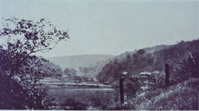
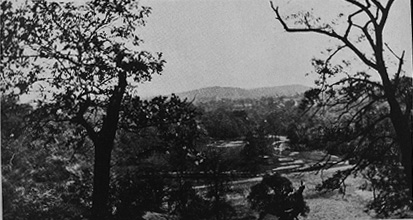
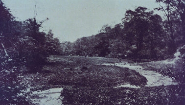
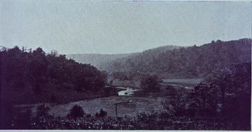
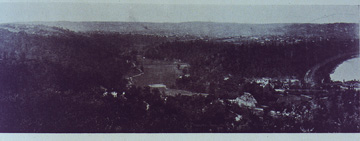
Exclusive of the northern end of Fern Hollow, the area of the ravines and valley within the city limits which would be involved in a full development scheme is approximately 474 acres. A part of the tract under consideration is included in the Frick Park bequest. The Pittsburgh Country Club has acquired the property indicated on the topographical map
(4)
Ordinarily the City of Pittsburgh could not alone be asked to seriously consider acquisition of this whole tract, because of the proximity of Schenley Park. However, the City should be interested in its development even though the project is essentially a metropolitan district one. Homestead, Swissvale, Edgewood, Wilkinsburg and the whole East End portion of Pittsburgh proper are specifically to be benefited. In order to facilitate the accomplishment of an extensive scheme of acquisition of park land in this valley, it would be highly desirable to secure the cooperation and participation of the various affected municipalities and of the industrial concerns which employ large numbers of workers. 
 

On page 69 is shown a suggested development of the valley. The wooded hillsides should for the most part be maintained and in places reforestation should be undertaken. No plan should be determined upon except after the most careful study and with the advice and assistance of the best landscape architect obtainable. There appears to be no doubt that, if carefully studied, a development plan could provide:

 
(a)
A proper treatment of thoroughfares through the tract as already noted. 
(b)
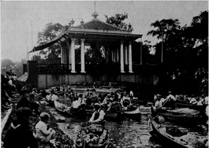
An ample lake for swimming and boating (see below). 
(c)
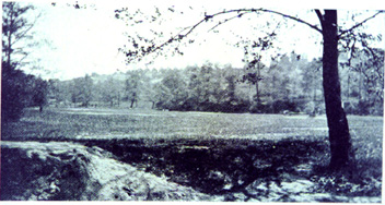
Open lawns for the use of large numbers of people. 
(d)
A special out-door swimming pool for exhibition swimming, to be part of an open air theatre, with seats upon an adjacent hillside. 
(e)
Recreation buildings or pavilions with restaurants, comfort stations, etc. 
(f)
Reserved space for athletics, such as baseball or football. 
(g)
A parking place for tourist automobiles, enclosed by trees and other planting, together with proper camping facilities for motorists. 
(h)
Picnic places in wooded or open spaces. 
(i)
Carefully located park roads (pleasure drives), few in number, through wooded or open spaces on the hillsides. 
(j)
A reasonable amount of park boundary line upon streets, both to facilitate access to the park and to maintain valuable park frontage for the residences upon such streets. 
(k)
A proper merger with, and coordinated development of, Frick Park. 
(l)
A botanical garden development in Fern Hollow. 
(m)
A sewage disposal plant near Brown's bridge, without undesirable effects, if such plant is later deemed necessary. 

 VIEW IN NINE MILE RUN VALLEY AT LOWER END OF COMMERCIAL AVENUE LOOKING SOUTHWEST
 (back to Table of Figures)
 
 VIEW IN NINE MILE RUN VALLEY, LOOKING EAST TOWARD SWISSVALE
 (back to Table of Figures)


 (back to Table of Figures)  
 
 (back to Table of Figures)

 
 (back to Table of Figures)
 LOOKING UP FERN HOLLOW FROM ITS JUNCTION WITH THE MAIN NINE MILE RUN VALLEY
 
Because the local river waters are undesirable for swimming, if not actually unhealthful and dangerous, precautions should be taken to assure safety. A special sanitary problem is involved in the proposal to create a lake. It will be evident to those familiar with this locality that the creation of a lake of any considerable size is impossible. The restrictions of area and topography indicate that, in the planning of this recreation center, there should be maintained an extremely well balanced and wise relationship between the area to be used for the lake, the area beside it to be used as a bathing beach, the areas to be used for athletic sports and the areas maintained as open lawns. Obviously the problem here is not one for piecemeal attention or to be entrusted to men not trained to solve such problems. In this respect the possibilities of successful results are identical with those of the Frick Park tract. For this reason and because the park tract really forms a part of the area under consideration, as shown by the accompanying sketch plan , the scheme of development should be studied as a whole.


 VIEW IN NINE MILE RUN VALLEY
 (back to Table of Figures)
 
 
To those who hold that the needs of industries and manufacturing concerns should be supplied in this valley, the Committee cites the utmost importance of the present proposal for the recreation of a very great working population in the metropolitan district. It is significant that the population within a reasonable distance of this valley is, according to the 1920 census, about 220,000.


The Committee recommends that a survey, studies, and plans be made at once by the proper authorities, and that steps be taken to acquire the land.


 VIEW IN NINE MILE RUN VALLEY
 (back to Table of Figures)